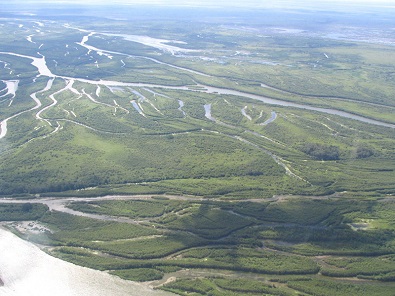
Photo of North Saskatchewan River. Photo courtesy of Jet Propulsion Laboratories and NASA.
Saskatchewan has been chosen by NASA as a testing ground for new technology on mapping water in northern environments.
NASA will use experimental radar to chart the water levels in the province’s wetlands and North Saskatchewan River. The prototype sensor will be used on a satellite mission set for 2021, which will map freshwater resources on the planet.
The University of Saskatchewan’s Hydrology Department will be involved, as it has brought together scientists from NASA, the Canadian Space Agency and two American universities for the project.
The first task for the research team will be creating an accurate calibration using on-the-ground measurements in correlation with airborne instruments, which are provided by the Jet Propulsion Laboratory in California. This will determine both the elevation of the river, slope of the bank and ultimately lead to a calibration for the satellite.
Al Pietroniro with the U of S says by determining the accurate height and slope of the river, they can try and estimate the velocity and flow in the river.
“We are looking at a focal point for Canada in hydrology research related to surface water and ocean topography right here in Saskatchewan,” said Pietroniro.
He says the project will have major implications on the way scientists monitor and predict the hydrology of the planet.
Prairie potholes formed by glaciers around the Saint Denis National Wildlife Area and Redberry Lake and the North Saskatchewan River, near the Petrofka bridge, offer researchers ideal locations to study and test of the new radar technology.
